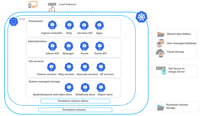
ArcGIS Enterprise on Kubernetes is a complete enterprise GIS implementation for the Kubernetes platform. It is a collection of microservices that represent foundational workflows, such as mapping, analysis, collaboration, and sharing. These microservices work together to accommodate and support software features and workload and are implemented as one or more Kubernetes deployments that are instantiated as pods in your organization.
Introduction
ArcGIS Enterprise on Kubernetes is packaged and delivered as a set of container images that run on worker nodes in a Kubernetes cluster. Pods are distributed across the nodes in the cluster and represent one or more containers.
For an overview of supported cluster providers on which ArcGIS Enterprise is supported, see the system requirements.
ArcGIS Enterprise on Kubernetes foundational aspects are described below. The diagram illustrates a Kubernetes cluster containing a namespace called arcgis. The namespace contains four categories of pods that represent various system functions. The diagram does not represent a complete list of pods or requirements; rather it depicts an overview of how the system is organized.

Framework
Framework pods support your organization's workflows and provide information for members of the organization to learn about the system through help documentation. These pods can also be scaled in their respective system deployments using ArcGIS Enterprise Manager or ArcGIS Enterprise Administrator API.
| Pod name | Purpose |
|---|---|
Ingress controller | Single point of entry into and directs traffic across the Kubernetes cluster |
Help | Step-by-step and conceptual documentation to deploy, configure, and use ArcGIS Enterprise on Kubernetes |
Services API | APIs for GIS, system, and utility services that support publishing, caching, and analysis workflows |
Apps | Foundational support for embedded apps in the organization |
Administration
Administrative pods provide the initial framework to create an ArcGIS Enterprise organization. Once your organization is up and running, you can scale these pods in their respective deployments using ArcGIS Enterprise Manager or ArcGIS Enterprise Administrator API.
With ArcGIS Enterprise Manager, administrators can monitor and manage various aspects of the organization. Administrators are provided with an active view of the organization through monitoring tools for system health, logs, and other critical information. ArcGIS Enterprise Administrator API is fundamental to the organization. It manages the life cycle of the ArcGIS Enterprise components and aids in operations across the organization.
Learn more about administrative resources and workflows
| Pod name | Purpose |
|---|---|
ArcGIS Enterprise Administrator API | APIs for administrative and automation aspects of the ArcGIS Enterprise organization. |
ArcGIS Enterprise Manager | Initially used as a setup wizard to create an ArcGIS Enterprise organization. Once the organization is configured, ArcGIS Enterprise Manager is used to manage, monitor, and secure the organization. |
ArcGIS Enterprise portal | User experience that supports sharing and item and member management workflows. |
Portal (sharing) API | APIs that support sharing, item management, and member management workflows. |
GIS services
GIS services enable the geospatial capabilities of your organization. GIS services include map, feature, and geocode services as well as hosted map and feature services. GIS services that reference user-managed data stores require an active connection to a registered data store. Hosted services are published using system-managed data stores. These pods, as well as those for system services and utility services, can be scaled in their respective service deployments.
Additionally, you can federate ArcGIS GIS Server and ArcGIS Image Server sites from Windows and Linux environments to add capabilities to your system.
| Pod name | Purpose |
|---|---|
Feature services | Supports editing workflows in maps and apps. |
Map services | Makes maps, features, and attribute data available in many types of applications. |
Geocode services | Supports workflows to search for and locate addresses and places on a map. |
GP services | Supports service tools for mapping and feature services. |
System-managed storage
ArcGIS Enterprise on Kubernetes deploys and manages system storage in the Kubernetes cluster. This storage is used for a variety of purposes such as hosted map and feature service data, portal content and indexes, system logs, and service usage statistics. System storage is deployed as stateful sets and typically binds to one or more persistent volumes via persistent claims to store data files. Administrators can configure the storage classes that are used by the persistent claims allowing administrators to control the size and kind. Cloud providers typically have a variety of volume controllers that can provision various types of volumes from network shares to block storage or disk.
The following pods are configured in the cluster to use storage from these persistent volumes to support various organizational workflows. At this release, storage pods cannot be reallocated resources or scaled. The limits on these pods are predefined by architecture profiles.
| Pod name | Purpose |
|---|---|
Object store | Stores uploaded and saved content, hosted tile and image layer caches, and geoprocessing output. |
Relational store | Stores hosted feature data and administrative aspects such as customization and configuration settings. Two relational stores are configured: primary and standby. |
Spatiotemporal and index store | Stores logs and indexes as well as hosted feature data that supports real-time and big data visualization and analytics. |