Available with Image Server
The Tasseled Cap (Kauth-Thomas) transformation is designed to analyze and map vegetation phenomenology and urban development changes detected by various satellite sensor systems. It is known as the Tasseled Cap transformation due to the shape of the graphical distribution of data.
The transformation provided a rationale for the patterns found in Landsat MSS data of agricultural fields as a function of the life cycle of the crop. Essentially, as crops grow from seed to maturity, there is a net increase in near-infrared and decrease in red reflectance based on soil color.
The utility of this transformation has expanded from monitoring crops to analyzing and mapping vegetation to support a variety of applications such as forestry, industrial vegetation management, ecosystem mapping and management, inventory and monitoring for carbon sequestering and credits, urban development, and more. It has also expanded from supporting Landsat MSS to include other popular satellite systems such as Landsat TM, Landsat ETM+, Landsat 8, IKONOS, QuickBird, WorldView-2 and RapidEye multispectral sensors.
There are several advantages for using the Tasseled Cap function:
- Provides an analytical way to detect and compare changes in vegetation, soil, and manmade features over short- and long-term time periods.
- Provides an analytical way to directly compare landcover features using satellite imagery from different sensors including Landsat, IKONOS, QuickBird, WorldView-2 and RapidEye
- Reduces the amount of data from several multispectral bands to three primary components: brightness, greenness, and wetness (or yellow stuff for Landsat MSS).
- Reduces atmospheric influences and noise components in imagery, enabling more accurate analysis.
Notes
The input for this function is the source raster. There are no other parameters for this function because all the information is derived from the input's properties and key metadata (bands, data type, and sensor name). Only imagery from the Landsat MSS, Landsat TM, Landsat ETM+, IKONOS, QuickBird, WorldView-2 and RapidEye sensors are supported. This function can be used on the items in a mosaic dataset, when using the associated raster types or when using the associated raster products.
Prior to applying this function, there should not be any functions that would alter the pixel values in the function chain, such as the Stretch, Apparent Reflectance, or the Pansharpening function. You may have to remove the Stretch function from the function chain as it is often added by default. The only exception is for Landsat ETM+; when using Landsat ETM+, the Apparent Reflectance function must precede the Tasseled Cap function.
If the data has been preprocessed, this function will not provide the correct results. It is best to use the raw data from the imagery provider. Also, the preprocessed 8-bit IKONOS, QuickBird and WorldView-2 data is not valid since the pixel values have been altered.
The output of this function will be the same data type and band count as input raster. Output bands represent the principal components rather than a spectral range. You can use the first three bands, as described earlier, as part of a further analysis, or use them to visualize the brightness, greenness, and wetness information.
Parameters
| Parameter | Description |
|---|---|
Raster | The input raster to perform the Tasseled Cap transformation on. |
Learn more about the Tasseled Cap Transformation
The Tasseled Cap Transformation was developed in 1976 by R.J. Kauth and G.S. Thomas of the Environmental Research Institute of Michigan (ERIM). In the paper (Kauth and Thomas, 1976), the transformation provided a rationale for the patterns found in Landsat MSS data of agricultural fields as a function of the life cycle of the crop. Essentially, as crops grow from seed to maturity, there is a net increase in near-infrared and decrease in red reflectance based on soil color.
In remote sensing analysis it is common to ratio and plot different combinations of multispectral bands to examine relationships between the bands. The Tasseled Cap transformation is a special case of principal components analysis which transforms the image data to a new coordinate system with a new set of orthogonal axes. The primary axis, called brightness, is statistically derived and is calculated as the weighted sum of reflectances of all spectral bands and accounts for the most variability in the image. Brightness is associated with bare or partially covered soil, man-made, and natural features such as concrete, asphalt, gravel, rock outcrops, and other bare areas. Orthogonal to the first component, the second component greenness is associated with green vegetation, while the third component wetness is orthogonal to the first two components and is associated with soil moisture, water, and other moist features. For Landsat MSS, the third component corresponds to yellow stuff rather than wetness, and represents mature crops ready for harvest, such as different grains, as well as vegetation senescence.
The other additional components contain image noise and atmospheric influences, such as clouds, haze, sun angle differences, and so on, that have been removed from the first three more significant components. The first three components of the Tasseled Cap transformed imagery contain about 97 percent of the meaningful information available in the image.
Below is an example of the Tasseled Cap function results from a sample image.
| Image | Description |
|---|---|
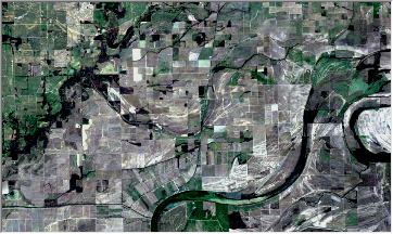
| This image was taken from a Landsat 5 TM scene. This scene was acquired on February 11, 2008, over a location in Arkansas, USA. This is a natural color-band combination (RGB, bands 321). |
| This the RGB combination of the first three components from the Tasseled Cap function. Red = brightness, green = greenness, and blue = wetness. |
 | This is the first component, brightness, displaying the low to high values using a color ramp from black to white. |
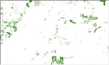
| This is the second component, greenness, displaying the low to high values using a color ramp from white to green. |
 | This is the third component, wetness, displaying the low to high values using a color ramp from white to blue. |
References
1. Kauth, R.J. and Thomas, G.S. 1976, The Tasselled Cap—A Graphic Description of the Spectral-Temporal Development of Agricultural Crops as Seen by LANDSAT. LARS Symposia, paper 159.
2. Crist, E.P. and Cicone, R.C., 1984, A physically based transformation of Thematic Mapper data—The TM Tasseled Cap, IEEE Transactions on Geosciences and Remote Sensing, GE-22: 256–263.
3. Huang, C. et al, 2002, Derivation of a tasseled cap transformation based on Landsat 7 at-satellite reflectance. International Journal of Remote Sensing 23: 1741–1748.


