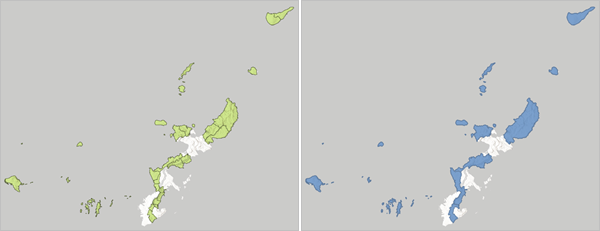
The Dissolve Boundaries tool finds polygons that overlap or share a common boundary and merges them to form a single polygon.
The output is a hosted feature layer.
Example
A GIS analyst requires a layer that maps the districts in the Kyushu region of Japan. However, the analyst only has a layer of Kyushu municipalities. Dissolve Boundaries can be used to create a layer of districts using the municipality layer.

Usage notes
Dissolve Boundaries includes configurations for input features, dissolve settings, and a result layer.
Input features
The Input features group includes the Input features parameter, which specifies the polygon features to be dissolved.
For feature inputs, a count of features is displayed below the layer name. The count includes all features in the layer, except features that have been removed using a filter. Environment settings, such as Processing extent, are not reflected in the feature count.
Dissolve settings
The Dissolve settings group includes the following parameters:
- Dissolve features with matching field values determines whether the tool dissolves only the polygons that overlap or share a common border and have the same field value (enabled) or all the polygons that overlap or share a common border (disabled).
- Create multipart features determines whether the output can contain multipart polygon features, meaning multiple polygons defined as a single feature (enabled), or can only contain individual features (disabled).
- Calculate statistics for dissolved features determines whether to calculate statistics for dissolved boundaries. If enabled, choose a number field from the input layer to summarize and the statistics to calculate for the field.
Summary statistics determines which number fields from the input polygon layer to summarize. Supported summary statistics include sum, minimum, maximum, mean, and standard deviation. The statistics are calculated for each boundary separately.
Learn more about summary statistics
Result layer
The Result layer group includes the following parameters:
- Output name specifies the name of the layer that is created and displayed. The name must be unique. If a layer with the same name already exists in your organization, the tool will fail and you will be prompted to use a different name.
- Save in folder specifies the name of a folder in My content where the result will be saved.
Limitations
Inputs must be a polygon layer. Lines and points cannot be dissolved within boundaries using the Dissolve Boundaries tool.
Environments
Analysis environment settings are additional parameters that affect a tool's results. You can access the tool's analysis environment settings from the Environment settings parameter group.
This tool honors the following analysis environments:
- Output coordinate system
- Processing extent
Note:
The default processing extent is Full extent. This default is different from Map Viewer Classic in which Use current map extent is enabled by default.
Outputs
Dissolve Boundaries creates an output hosted feature layer with the dissolved polygon features. Depending on the tool configurations, the polygon layer includes fields with the following information:
- Count of polygons
- Summary statistics
- Area
Licensing requirements
This tool requires the following user type and configurations:
- Creator, Professional, or Professional Plus user type
- Publisher or Administrator role, or an equivalent custom role
Resources
Use the following resources to learn more:
- Summary statistics
- Dissolve Boundaries in ArcGIS REST API
- dissolve_boundaries in ArcGIS API for Python
- Summary Statistics in ArcGIS Pro